I forget the number of times a stranger has said to me after I told them what I do for a living, “oh, yeah, I wanted to be one of them as a kid”, or “I wish I knew that was a career option”. The small sense of pride I get from being an archaeologist in that situation is often humbled in the commonly followed sentence, “nah, yeah, I love dinosaurs, aye”. Being lumped in with Jurassic Park is only marginally better than being compared with the infamous archaeologist in name only, Indiana Jones. At least Time Team gives you an idea of what archaeology is actually about.
Now, unless you are my Mum and Dad, you are either lost or are reading this with an interest in heritage and archaeology or are at least curious to know what all the fuss is about.
Before we go any further, let’s consider what archaeology actually is. Like any profession run by people with too much time to think, archaeology has many definitions. I meekly offer the following:
Archaeology is the study of the physical remains left behind by people in the past to learn more about those people.
Sexy, I know. Before we move on, there is a bit to unpack here. Physical remains are much more than those awe-inspiring monuments that have entered your mind at least once while daydreaming through this post.
I mean the Pyramids of Giza, Stonehenges, Angkor Wats and Mayan temples of this world. Archaeologists can really study any physical remains from the past that people created, altered or used.
Those material things can really be anything preserved since the time of our most ancient of ancestors to what you forgot to clean up last week. If you can learn something about the human past by studying it, you can consider it archaeological.
Now we are on the same papyrus (ha… because it’s old), let’s dive a little bit deeper. We commonly refer to archaeological remains that you can pick up without them falling through your hands (not because you are clumsy) as artefacts (artifacts in North America). Artefacts can include stone tools, carved wooden objects, decorated pots or even preserved clothing.
Those things that you cannot pick up, we refer to as features. These are things like buried house floors, filled-in post-holes or the charcoal and stone piles left from cooking fires.
In Aotearoa New Zealand you may also hear artefacts and features referred to as “taonga”, which is a term encapsulating the value of those objects for tangata whenua (Indigenous Peoples of Aotearoa, people of the land) as a manifestation of our ancestral connections. A taonga, here, refers to the artefact or feature being a “treasured thing” passed down from an earlier generation. Whatever terminology you use, taonga, artefacts and features are a physical connection to our past.
Archaeological techniques
What about the second part of the wondrous archaeology definition offered above. The general intent of doing archaeology is to learn more about the past. Against common understandings, archaeology is not just digging stuff up because it will look nice on your mantelpiece (although I cannot speak from our discipline forefathers).
Archaeologists excavate the ground to carefully observe and record the contexts in which artefacts and features are positioned. That context, that layering of the physical evidence, is fundamental to our understanding of how those artefacts and features fit into the bigger picture of who, when, how and why people did what they did at that location. If that object is removed from it’s archaeological context without being recorded, our ability to understand its story is significantly diminished.
If you are taking notes, write “context is everything in archaeology”.
But it’s not all just about excavation. Archaeologists use a vast array of techniques that we have borrowed from other fields of study. Let’s briefly consider a few.
Geochemical signatures of stone artefacts can be detected to identify where they were originally sourced from.
LiDAR (Light Detection and Ranging) can allow surface survey of archaeological evidence from afar, even allowing us to sometimes “see” through vegetation.
One of my favourites is the use of aerial and satellite images. Although most archaeological evidence is buried below the ground, we can often see the “tip of the iceberg”, as it were, on the surface. That surface evidence may include the earthwork remains of pā Māori (Māori settlements), buried building platforms, disused road alignments or agricultural stone walls.
Other techniques include the use of geophysics to detect buried features based on their electrical resistivity, magnetism or density (radar wave reflection). These can help detect the edges of cemeteries and urupā for preservation and protection or identify buried hearths that are no longer visible on the surface.
Mosaicing the past
Perhaps you are thinking, but surely, we already know what there is to know about the past. I mean, we have histories shared by kaumātua and kuia (elders), or that we can find written in books or online, right?
Absolutely, there are so many ways to engage and learn more about the days gone by. Archaeology is but one of these. Through archaeology, we can explore when events happened in the past where there is no record, or shed light on the practices of those people that were not politically important enough to be included in official histories.
In my opinion, archaeology does not stand above these other ways of knowing what went on before. It is just another source of tesserae (those teeny bits of ceramic, shell or glass), albeit an important one, that we can use to build that incredible mosaic of the past that stands before us.
Although archaeology focuses on the physical evidence of the past in the form of artefacts and features, archaeology functions within a broader suite of how we can relate to those gone before. These same objects may be a source of information to one group and foundational to another group’s identity and sense of belonging. Through carefully designed projects with power sharing, inclusive new understandings of the past are possible through archaeology.
Thoughts to take with you
So, now you are armed with a bit more information about archaeology for your next pub quiz. It has nothing to do with dinosaurs – that’s palaeontology. It does have a lot to do about the past, however. The past stands before us in physical form as a reminder of who we are and who we come from. Archaeology is the study of that material to learn more about the people who made it, altered it or used it. Remember context is everything. Stay tuned for more.
There is a growing respect for the history of Aotearoa New Zealand with the uptake of a new history teaching curriculum and initiatives like Te Pūtake o te Riri (New Zealand War Commemorations).
With the growing attention on the relatively short history of settlement in the country, you may be thinking that we know all there is to know about the past and now it’s just a case of learning it.
Oh no, my friend! With each passing year, new understandings are brushed off and debated, enabling fresh insights into who we are and how our society formed in the way it did.
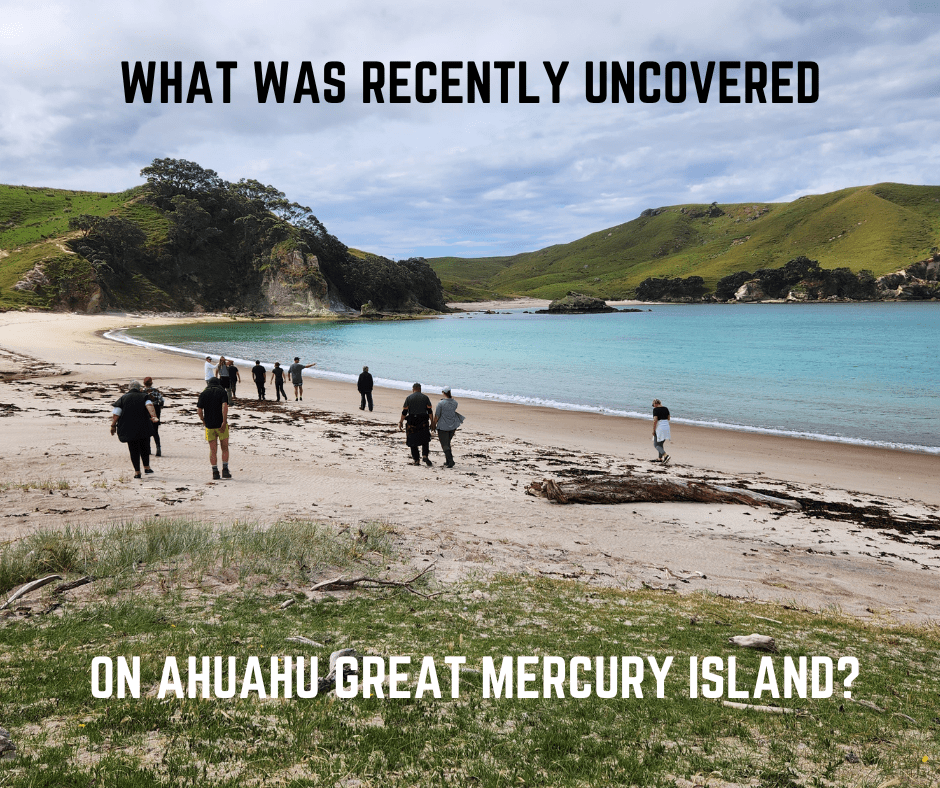
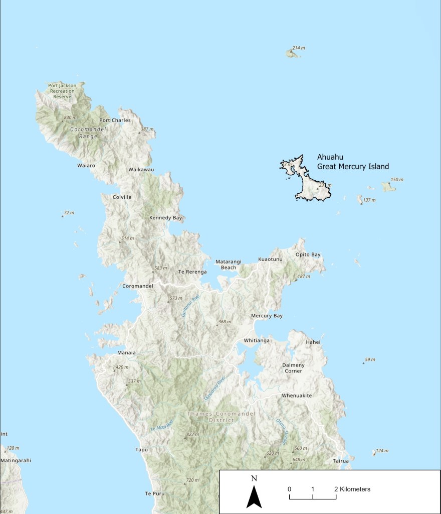
One significant place where our knowledge of the past has grown significantly over the past decade or so is Ahuahu (Great Mercury Island), located offshore of the Kuaotunu Peninsula on the east coast of the Coromandel Peninsula.
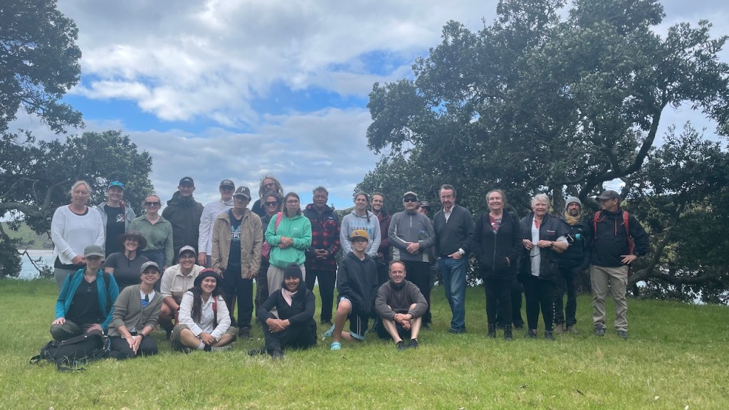
Fortunately for you, dear reader, just a few months ago, an archaeological expedition went out to the island joined by Ngāti Hei to hīkoi (tour) around significant sites. So, what goes on at Ahuahu, what was uncovered in November 2023, and why should you care? Find out below and read the words of one Ngāti Hei uri (descendant) who joined the hīkoi.
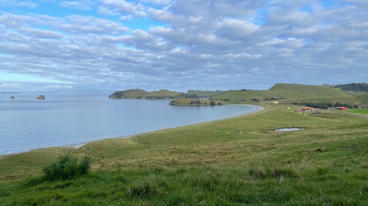
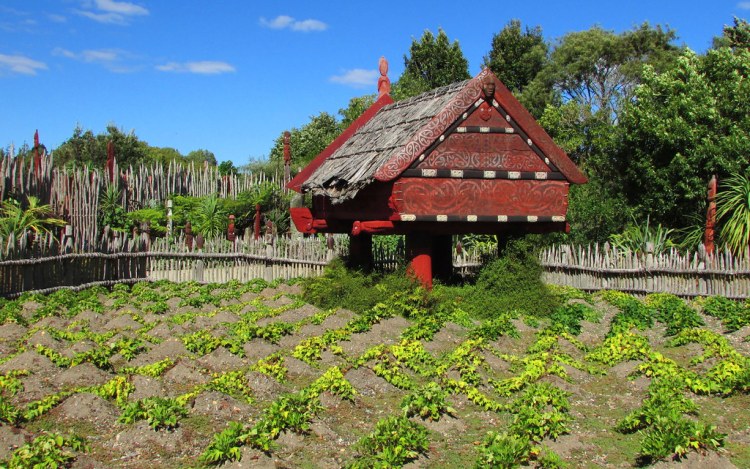
View northwards along Oneroa beach from above Waitetoke towards Matakāwau (Stringray Point) Pā. Note the wetland to the right, which is the area in which taro was formerly cultivated. Credit: Emily Harvey.
There was a sense of awe, in seeing the terraces of headland pā, and thinking of all the work in creating those kainga, still visible after so many centuries.
Tiki Johnston (Ngāti Hei)
The archaeology project
Several kōrero tuku iho (inter-generationally transmitted oral histories) describing the Polynesian migration events from Hawaiki (the ancestral homeland) to Aotearoa refer to Ahuahu as a critical place associated with early settlement on the eastern coastline of Te Ika-a-Māui (North Island).
Today, many hapū regard Ahuahu as a significant place in their histories — as whenua tūpuna (ancestral land) providing a link between kanohi ora (living people) and ngā mātua tūpuna (ancestors). The iwi (tribe), Ngāti Hei, has a deep and persistent historical connection to Ahuahu and partners with current island owners, the Fay and Richwhite families, and the University of Auckland’s Archaeology Department to learn more about the island’s history.
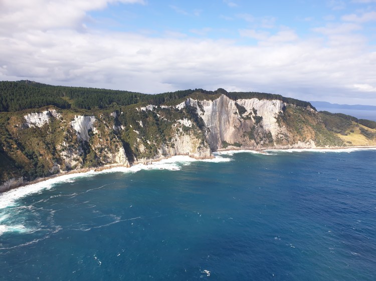
Pari-nui-te-rā: the great white cliffs on the eastern side of Ahuahu are recorded in several kōrero tuku iho to be one of the first sights for early Polynesian voyagers of Aotearoa.
The current bout of archaeological research on Ahuahu (earlier work having been undertaken by Jack Golson in 1954, Steve Edson in 1972–1973 and Geoffrey Irwin in 1984) began in 2012. On a personal note, this was also the year that I first put trowel to land in the archaeological field school, galvanising my passion for archaeology.
In November 2023, Professor Thegn Ladefoged led an excursion of researchers from the University of Auckland and the University of Otago back to Ahuahu to further investigate an area known as “Takapau” and “Waitetoke”, located on the tombolo between two larger bodies of land on the island to the north and south.
Ahuahu/Great Mercury Island is located off the east coast of the Kuaotunu Peninsula on the Coromanel Peninsula and is the location of an archaeological research project partnered by Ngāti Hei, current island owners, the Fay and Richwhite families, and the University of Auckland’s Archaeology Department.
This phase of research was part of a Marsden-funded project led by Te Pūnaha Matatini (a Centre of Research Excellence studying complex systems) with the aim of understanding the complex ways in which Māori in Te Ao Tawhito (before European contact in the late seventeenth century) interacted and formed their environments and ultimately became changed by those environments. No small task!
Takapau and Waitetoke
View of the Takapau stone alignment remains running down and across the slope above the wetland to the left. Note the rushes and darker green grasses in the middle right, which are a clue of the puna that once fed the taro and kūmara māra kai. Credit: Quinta Wilson.Aerial photograph of the same stone alignments, terraces and wetland at Takapau/Waitetoke taken from a drone (provided by Prof. Thegn Ladefoged).
Previous work had recorded a series of stone-faced terraces, stone alignments and evidence of buried cultivated soils. These were all that remained of generations of industry by tangata whenua who had first settled the area, cleared the forest, planted introduced food crops, and tended their cultivations — i.e., making a home.
Led by Dr. Matiu Prebble, detailed inspections of microscopic plant and insect remains preserved in soils had already revealed that tangata whenua had actively cultivated taro and kūmara — crops that had been introduced to Aotearoa from Hawaiki by Polynesian voyagers — at that very spot.
The evidence suggests that after the rimu dense island forests were cleared from the area, the tropical crop, taro, was cultivated between 1425 and 1600 CE. After this time, people favoured kūmara, probably because it is more hardy and produces more food than taro in northern temperate Te Ika-a-Māui.
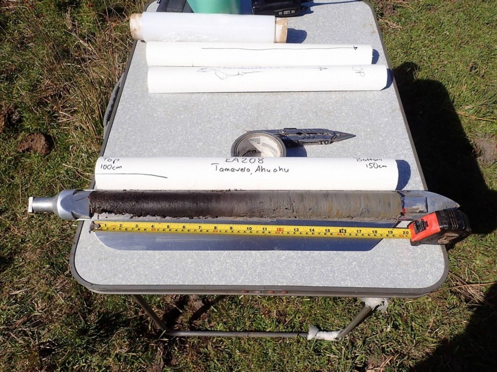
All this information about the old people came from a few sampled bags and cores of dirt! Amazing!
Sediment cores can provide a window into the past, helping us reconstruct changes in landscape erosion, vegetation, cultivation and more. This is an example archaeological sediment core from Tamawera (Tamewera), Ahuahu (provided by Prof. Thegn Ladefoged).
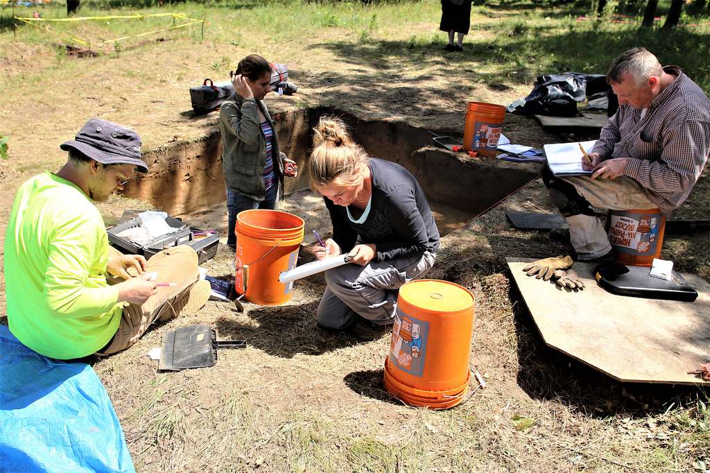
November 2023 Fieldwork
During the waxing moons of Whiringa-ā-rangi (October-November) of the maramataka Māori (lunar calendar) and under the mana of Ngāti Hei, the archaeology team set to work to further explore the limits of the former cultivations that had been planted over several seasons perhaps under the same Whiringa-ā-rangi lunar phase, several hundred years before.
We laid several excavation trenches that had not been completed in earlier excavation seasons. Wait, wait…That’s a funny thought — What does it take to finish a trench???
Well, archaeological excavations are destructive, an idea that is at the forefront of a good archaeologist’s mind when planning any excavation. If we are to disturb wāhi tūpuna (ancestral places), we need to ensure that we record what is uncovered in detail to preserve that information.
The trade-off in recording in great detail is that hand excavation can be slow (think hearth brushes and hand trowels!). Without such care and patience, important clues can be lost in the spoil piles of an overly excited digger. When time is up, and a trench has not been excavated fully through the “cultural layers” of sediment deposited or made by human activity, archaeologists cover unfinished trenches with a cloth or tarpaulin that can be easily relocated.
What did we find?
Once excavations were in earnest, the team excavated and recorded remains of kūmara and taro cultivation beds, irrigation trenches, fire features, post holes and stone artefacts. Despite what I have said before about midden, we recovered very few food remains in the form of bone and shell. Today, let’s focus on the evidence of māra kai (food cultivation).
Maybe you have done some planting in your mum’s yard or out back of the marae, but what would your great, great, great, great, great grandparent’s cultivation beds look like today?
Example of a contemporary Waikato māra kumara and pātaka (raised storehouse) at Te Parapara, Kirikiriroa (Hamilton).
Past māra kai can be identified by looking for stone alignments on the surface, where gardeners had clear surface stones and stacked or aligned them in certain ways to possibly reflect whānau plots, limit surface erosion of precious soils or increase local soil fertility through leaching. Stone alignments are clearly visible at Takapau — so much so that the place name uses the imagery of a chiefly woven mat to describe the criss-cross pattern of stone walls here (refer to aerial image earlier in this post).
Māra kai remains can also be detected by excavating a trench into the ground and checking out the exposed vertical profile of sediment. At Takapau, we observed the tell-tale signs of cultivated soils with charcoal chunks from tilling burnt-off vegetation after initial forest clearance or periods of fallow (when lands were let rest for a period to naturally restore soil fertility). We also saw streaks of underlying sediment within the soil layers themselves, where gardeners had tilled through the soil layer.
View of an excavation trench (2 x 1 m) from November 2023 at Takapau/Waitetoke, Ahuahu. Note the fire feature in the profile, the excavated post hole to the left and the cleared-out kō marks below the cultivated soil into the underlying red-brown natural sand. The dark brown layer to the left is unexcavated cultivation soils (rich in charcoal fragments), while the deep hole to the right appears to be an earlier and deeper layer of gardening cultivated before the laying of the fire feature. This all indicates the layering of plant cultivation practices through time. The radiocarbon dates will tell us more about this chronology!
Not only did we detect this streaking pattern, but we also detected the marks of that tilling action below the garden soil, where kō (cultivation implement) had scraped against the underlying sediment. These are some of the special occasions as an archaeologist where you can see the remains of a single person’s action — digging in the māra kai. I have worked as an archaeologist for over a decade, and these connections with those gone before still strike me and make my hair stand on end.
Another cool aspect of the excavation was uncovering the remains of irrigation ditches! So, not only were tangata whenua actively clearing, planting cultivating at Takapau and Waitetoke, in early stages they also actively managed the flow of water from a puna (spring) to irrigate taro crops.
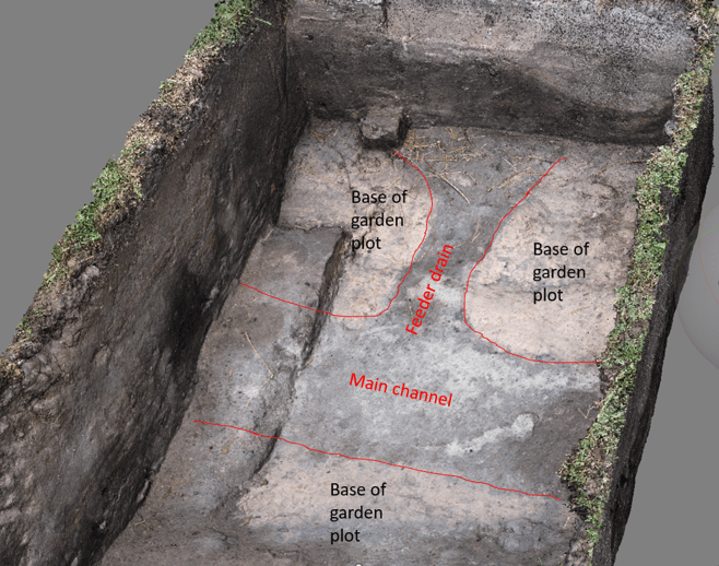
Three-dimensional model of the exposed irrigation channels filled with darker sediment than the natural light yellow-grey colour. This model was generated using a technique called photogrammetry, which stitches images of an object or surface taken from different angles together to create a 3-D model. This particular trench was excavated in earlier seasons (image provided by Prof. Thegn Ladefoged).
These irrigation channels were not visible on the surface and were not known to have been there today. However, through careful archaeological research on Ahuahu, work over recent years and continued this year have uncovered and carefully documented these channels to explore their capacity, function and alignments to build a comprehensive understanding of their importance in relation to the taro cultivation here.
Archaeological evidence of irrigation is not too common in Aotearoa and is much more widely practiced in the tropical Pacific, like the great pond fields of windward Hawai’i. Each instance demonstrates localised innovations and dynamic environmental relationships by the tāngata whenua and kānaka moali.
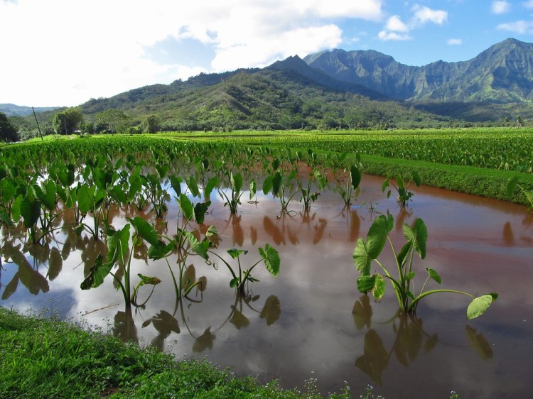
Microfossil plant remains of taro were found in recent research on Ahuahu. This is an example of extensive taro pondfields managed today in Kuai, Hawai’i.
Why is this work important?
I offer you two reasons:
The results of this ongoing research project contribute significantly to our understanding of tangata whenua histories of settlement in Ahuahu and Aotearoa. This localised study of māra kai provides information on plant introductions, climate adaptations and innovations that remain relevant to our changing world today.
The archaeological research is an opportunity for Ngāti Hei and other interested iwi to learn more about the achievements and lives of their ancestors. Kōrero tuku iho tells us so much about the past, but archaeology can provide glimpses of the lives of those perhaps not recorded in the histories while providing overarching narratives of change through time over hundreds of years. Both forms of knowledge have a place in understanding the past.
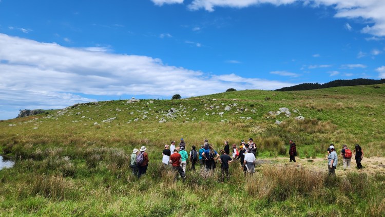
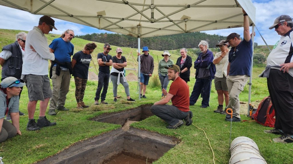
Whitiwhiti kōrero (discussion) about the ancestral māra kai cultivation remains at Takapau and Waitetoke, Ahuahu. Credit: Quinta Wilson.
The significance of Ahuahu and the findings of the archaeological research progress was clear when Ngāti Hei joined members of the research team in discussing trenches exposing the remains of māra kai and going on an island-wide hīkoi (excursion) to places of significance.
Mātauranga and archaeological information was offered and discussed. But beyond the knowledge, were new senses of connection amongst ngā hunga ora (living people) and with ngā hunga mate (those passed) made possible through engaging with place, archaeological practice, kaitiakitanga (stewardship) and whanaungatanga (relationship building).
Tiki Johnston (Ngāti Hei) offers her perspective of the trip in her own words:
It was a privilege for us as Ngāti Hei iwi members to spend time with the Ahuahu Archaeology Project kaimahi out on Ahuahu. Thanks for all the planning, and for the boat trip – which was also a great chance for whakawhanaungatanga and sharing of kōrero, as we passed through our rohe moana, and looked out at motu we have heard much about – Ohinau, Whakau, Ahuahu. Thanks also for the delicious lunch!
Group shot of Ngāti Hei, Sir Michael Fay and the research team. Credit: Dion O’Neale
It was a wonderful experience for our whānau to share kōrero and mātauranga, on Ahuahu – which we have heard spoken of as “our Hawaiki” – as the place our tīpuna came to, and then from. I’d heard stories of this place of bounty, where kūmara were so plentiful they could tumble from the cliff into the waka, this kōrero came alive as we moved through the landscape.
The painstaking work of the archaeologists was explained patiently and clearly. Through this mahi we had a glimpse into the lives of our tīpuna – their hard work, their ingenuity, their adaptability – changing the landscape, using rock, water, and fire to create cultivations of taro and kumara from such early times. It was a profound experience to see the great, white rhyolite cliffs – Pari-nui-te-rā — which we have heard were the signal for waka in ancient times that they had reached their destination. There was a sense of awe in seeing the terraces of headland pā and thinking of all the work in creating those kainga, still visible after so many centuries. We could see the landscape is so rich in history, and learning about your work gave us a window into the lives of our earliest tīpuna. While for me, it was my first time on Ahuahu, it also felt like a homecoming — to our ūkaipō. Nā reira, e ngā ahorangi, e rere kau ana ngā mihi hōhonu ki a koutou.
Thank you for reading this blog post. As always, share this page with a friend and be sure to subscribe, so you don’t miss the future fuss. Ka nui te mihi atu ki a Tiki rātou ko Ngāti Hei whānui anō. He mihi hoki ki ngā iwi maha e hono ana ki Ahuahu. Whēoi anō me ngā mihi nui atu o te tau hou Pākehā ki a koe, ki a koutou katoa, nā Zac.
Perhaps before you have a read, how do you think different types of cultural heritage places are protected, revered and celebrated in this country?
Tangata whenua – of the land,
Mount, river, sea recite.
By song and chant, tuku iho,
Self-knowledge, day and night.

Manaakitanga, wealth to the guest,
Gathered from bush and coast,
Where tū-puna maintained and cared,
Their footprints marked by post.

From afar they came ashore,
Mixed welcome or resenting.
Southward all to bounty learned,
Agreement sealed by penning.

Be hail’d norward red and blue,
Forefather strength admire.
Fuss be gone, broke in the land,
Crate wool, numb’r-8 wire.

Four generations rest their head,
Hence this be their true home.
Though light skin be with foreign tongue,
Law bind from beehive dome.

A land taken from the centre,
Homes cut up, distributed.
Those gone before now set aside,
Their language all but muted.

New buildings on the edge of earth,
Made firm of stone, alloy,
Celebrated for industry,
Protected, all enjoy.

Those here before, buried below,
Places destroyed or gone.
Deep within a private farm,
Not marked, must be a con.

Inequity in what we guard,
And the power of the system.
All history schools now bestow.
Grow youth beyond our wisdom.
The current evidence suggests that Polynesian voyagers — the ancestors of today’s whānau, hapū and iwi Māori — settled in Aotearoa New Zealand between 1250 and 1300 CE.
We know this from whakapapa (genealogies), radiocarbon dating of archaeological sites, sedimentary environments and tephra deposits, as well as black carbon trapped in Antarctic ice layers!
If you know an archaeologist in Aotearoa New Zealand, you will probably have heard the old claim that archaeology in New Zealand is important because it is one of the last major land masses to have been occupied by people! Let’s set aside the alternative narratives for now…
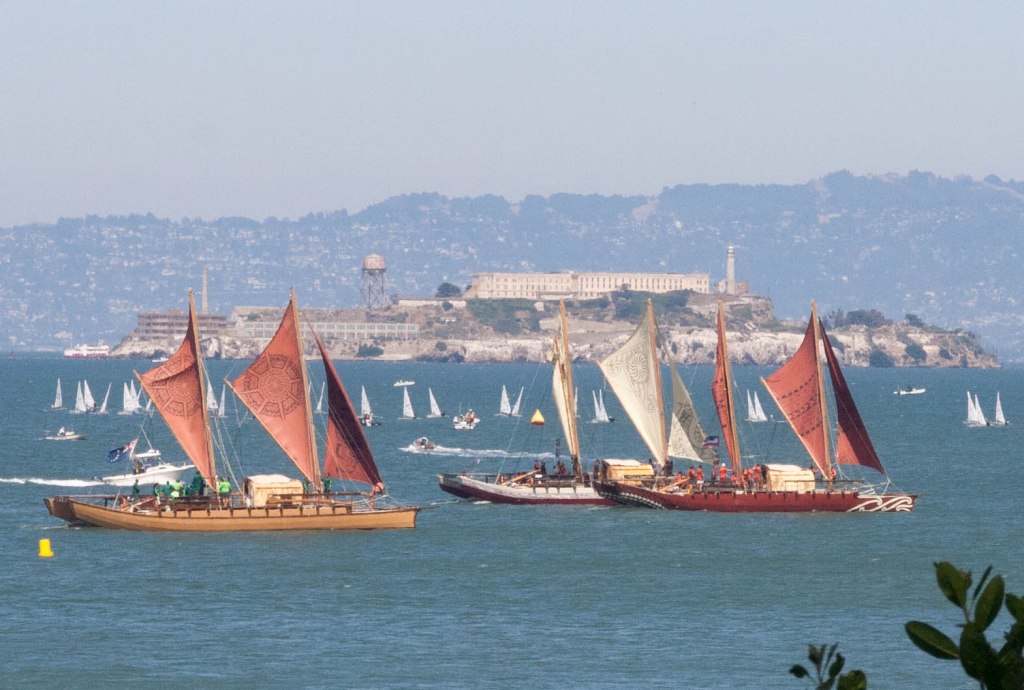
How do we know Aotearoa New Zealand was settled relatively late in the human story? How do we actually know that? I will flip the script a bit here and explore the second question first. Crazy, I know…
Polynesian voyaging waka (canoes) in San Francisco Bay
Whakapapa: the who of the ‘when question’
As you know, the descendants of those expert voyagers who successfully traversed Te Moana-nui-a-Kiwa (Pacific Ocean) to reach Aotearoa became the whānau, hapū and iwi we know today.
There is a rich and webbed vine-work of genealogical connections connecting descendants and ancestors vertically and whanaunga (relations) horizontally. This whakapapa is also the framework on which kōrero tuku iho (intergenerationally transmitted oral histories) are draped — at once proving social membership, belonging, political claim to land and recalling long-lasting bonds between hapū.
Believe it or not, whakapapa has been expertly maintained over centuries to preserve migration narratives to Aotearoa New Zealand.
There are several techniques in which you can relate your whakapapa to calendar years. A common way of doing this (having been done since the nineteenth century!) is to count generations back in time and assign each one an average generation length.
Using this technique, in Tangata Whenua, Atholl Anderson evaluated the estimated arrival dates of many different migration traditions, finding them all to relate to the period from 1250 to about 1450 CE.
Another modern network approach uses the complex interlaced and overlapping web structure of whakapapa to estimate how precise we can be about when individuals were born in the past. I developed this approach as part of my PhD research in Te Pua Wānanga Ki Te Ao (Faculty of Māori and Indigenous Studies) at Te Whare Wānanga o Waikato (University of Waikato) and will explain how it works another time.
Different iwi have varying accounts of who were the first explorers to arrive in Aotearoa New Zealand, such as Māui-tikitiki-o-taranga, Kupe and Toi-te-huatahi. Subsequent waka arrived at various times. However, probably not all at the same time as Percy Smith proposed in what was later called “the Great Fleet myth”. That being said, scholars still debate whether there was an initial mass migration event or not.
An introduction to whakapapa Māori by Tuihana Pook, Tihirangi Brightwell and Hine Waitere.
Radiocarbon dating
Often described as the “workhorse” of archaeology, radiocarbon or carbon-14 dating is a powerful tool to estimate when events from up to 55,000 years ago occurred in the past based on organic remains that still exist today.
The basic idea of radiocarbon dating is that all living things have carbon atoms in them. There is a particular type of carbon (known as a carbon-14 isotope), which is unstable (radioactive) and constantly changes into other atoms (including the stable carbon-12 atom).
The unstable type of carbon is constantly taken up in the atmosphere by birds, bees, plants and trees. But, on the sad day that those living things die, they stop taking up that unstable carbon from their surroundings.
Now, that unstable carbon keeps turning into other atoms inside the dead tissue, bones, wood, seeds, leaves or shell (any organic remains) of that once-living being. That change happens at a more or less (very much more and very much less) constant rate.
You guessed it! Archaeologists — well, actually radiocarbon dating specialists, beginning with Willard Libby in the late 1940s — can count the number of unstable carbon in a sample of shell, wood or bone (etc) and estimate when that critter died in the past.
There are a few complicating factors, including how to calibrate the date according to where the unstable carbon came from in the organism’s environment, what that date actually represents and many other things. But, that’s the crux of it. If you want a little bit more info, check out the video below!
Okay, now we are on the same page, how has radiocarbon dating been used to date when Polynesians first settled in Aotearoa New Zealand?
There are lots of different forms of organic remains in early Polynesian settlements in Aotearoa New Zealand that have been radiocarbon dated. These include the preserved remains of charcoal in umu or hāngi (earth ovens), shell from midden, seeds within deposits modified in some way by people, bone from animals that were killed and eaten, and even moa egg shells!
The trick of using radiocarbon dating to date a particular event of past human activity is to be very careful about what you are dating. Say you have donned your leather hat, and you are part of a team of archaeologists who have come across a shell within an early site…
Can you be sure that shellfish died at the time that people were living there in the past? Are you sure that it isn’t just a naturally occurring beach shell? Was that charcoal burned from a natural fire? Is that wood driftwood or part of a house?
These are all questions that archaeologists have to grapple with (and so much more!)
So far, the earliest radiocarbon dates are from Wairau Bar, Te Pokohiki-o-Kupe, and relate to the late 13th century or as early as about 1280 CE.
Wairau Bar – early evidence of human settlement in Aotearoa New Zealand
Mud cakes
Lakes, peat bogs, estuaries and swamps have sediments that can build up slowly over time as water sources (slope wash from rain, streams, rivers, waves) wash dirt into them, which settles and can remain undisturbed in layers over sometimes thousands of years.
Tiny plant remains (microfossils like pollen, starch grains or phytoliths) can be caught up in that sediment, telling us what plants were growing in surrounding areas at different times.
Charcoal from fires nearby can also wash in — locking in information about possible human activity nearby. After all, where there are people, there are fires (for cooking, clearing bush for agriculture, hunting and general environmental management).
Researchers can take long vertical column samples called cores of these sedimentary environments to capture that archive of change through time in vegetation, sediment deposition and fires. Particular markers of human activity, like the introduction of an exotic plant species, an increase of regenerating shrubs and ferns, or indications of increased erosion, can be radiocarbon-dated to indicate when people first arrived in an area.
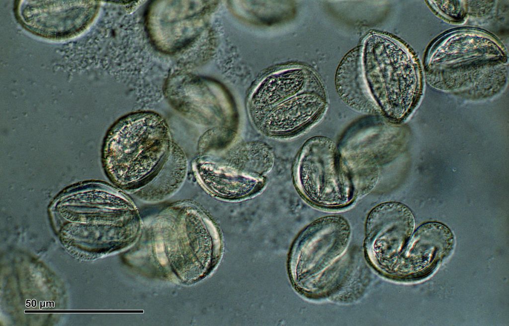
Pollen (from pine) under a microscope! This is the sort of stuff that can be trapped in lake sediments
“It burns us, precious”: Tephra
Ever seen a photo or video of a volcanic eruption? There are often big clouds of what looks like smoke, right?
Tephra being blown into the sky!
Those clouds are full of volcanic ash called tephra. When that tephra eventually falls to the ground, it can form layers on the ground surface, covering massive areas. If that tephra goes undisturbed, it can be sealed in place by other sediments deposited on top.
That tephra can then be sampled and dated very precisely and serve as important chronological markers for archaeologists interested in understanding when important events or processes occurred at a particular place.
In Aotearoa New Zealand, the Kaharoa eruption is a particular volcanic eruption from Mt Tarawera that is a critical chronological marker for when people first arrived. This is, of course, not to be confused with the famous eruption of Mt Tarawera in 1886, which destroyed the Pink and White Terraces.
There is still no archaeological evidence of any human activity below the Kaharoa tephra layer, which was deposited particularly across the eastern and northern Te Ika-a-Māui (North Island).
Fortunately, Professor Alan Hogg and his team found a tānekaha (celery pine) log within the Kaharoa deposit which was precisely dated to 1314 ± 12 CE.
An example of the Kaharoa ash layer shown here as a white band within this profile. No evidence of human activity has been securely identified beneath an undisturbed section of this tephra layer.
Layers of ice!
More recently, Joseph McConnell and others have identified black carbon (like soot from your chimney) deposits from fires in Aotearoa preserved in ice caps in Antarctica! How amazing is that?!
Using a series of chemical changes and cross-checking with other volcanic chronologies, the researchers could effectively count years of snow and ice build-up and measure how much black carbon from fires was trapped in each year’s deposit.
Using this technique, they identified evidence of periodic natural burning before 1297 ± 30 CE (s.d.), after which there was a massive increase in burning, indicating the arrival of people to Aotearoa.
Example of black carbon Greenland glacier ice. Black carbon is visible in Antarctic ice sheets that can be tied to the timing of first human settlement in lower Southern Hemisphere regions, including New Zealand.
So, when does all this point to?
The current consensus of when Hawaikiian voyagers first reached Aotearoa New Zealand is between 20 and 40 generations ago, or sometime between 1250 and 1300 CE. This is based on independent dates from whakapapa analysis, radiocarbon dates from archaeological excavations, sedimentary environments and tephra deposits, as well as black carbon in Antarctic ice caps.
Is it possible that people were here before then? Sure! However, they would have to be at very small population levels, like the explorers of Māui, Kupe and Toi, to not leave a significant mark on the environmental and archaeological record.
We will never identify the year when the first foot set to sand, fire was lit, or settlement was erected. However, what we can see are several overlapping lines of evidence indicating people making a new home across the country in the late 13th century.
Thanks for reading this blog. If you like what you see, hit the subscribe button and share this site with your mates who may be interested in New Zealand’s cultural heritage and archaeology. Aku mihi!
There are a growing number of “alternative histories” in Aotearoa. Some are new and… creative…, while others are recycled over and over from the nineteenth century despite repeated debunking.
A common theme of these conspiracies is that there was another ethnicity of people on these islands before the Polynesian voyagers successfully navigated the great expanse of Te Moananui-a-Kiwa (Oceania), and reached Aotearoa/Te Ika-a-Māui (North Island), Te Waipounamu (South Island), Rakiura (Stewart Island) and Rēkohu (Chatham Islands).
These theories may be driven by innocent curiosity, the thrill of trolling, a general resistance to authoritative narratives, or a political desire to undermine tangata whenua Indigeneity.
Today’s focus is the “Kaimanawa Wall”. For those of you thinking, hasn’t this story already been debunked? Yes, it has… over a quarter-century ago (I refer you to Neville Ritchie’s brief but comprehensive report on the “New Age Myth” for more detail than I include in this blog post).
That being said, alternative theories still clog up internet chat rooms and comment sections, so here is a bit more fodder to add to your sceptical musket.
Where are we?
Tuatahi, ka nui te mihi ki ngā tangata whenua ko Ngāti Tūwharetoa o te pae maunga ko Kamanawa. First, I acknowledge the mana of Ngāti Tūwharetoa – the tangata whenua (Indigenous people of the land) around the country’s largest lake, Taupō-nui-a-Tia and the Kaimanawa Range.
Deep within the Kaimanawa Forest Park is a “stack” of stone “blocks” that appear to have been placed there as a wall.
Although the “Kaimanawa Wall” is not actually a wall made by people, the area is significant to Ngāti Tūwharetoa, which should be respected.
The claim
The claim is that the rock slabs were shaped and assembled to form a wall for an unknown purpose. The joints between the slabs resemble walls at Machu Pichu in Peru, Rapanui (Easter Island) and elsewhere.
If the wall was indeed constructed by people, it surely must have been associated with pre-Māori culture… Surely… Right?… Guys?
Before we get carried away, the below image is an example image of a stone wall at Machi Pichu, Peru, and is not the Kaimanawa Wall.
Example of neatly fitting blocks that have been shaped to form a wall at Machu Pichu, Peru.
How did the claim arise?
In a 1996 article in The Listener, the historian Barry Brailsford argued that the “Kaimanawa Wall” was evidence of the “Waitaha” tribes, who he claimed arrived in Aotearoa some 2000 years ago but were defeated by the arrival of Polynesians whose descendants became tangata whenua (iwi and hapū Māori) today.
His theories about Waitaha have been discredited and I may explore the problems behind Brailsford’s claims at a later date with you. But, for now, just understand that Brailsford considered the “Kaimanawa Wall” to be “the best (physical) evidence so far” of the pre-Māori “Waitaha”.
The “wall” was dismissed as too early for Europeans and Māori, not to mention it being unlike other evidence of tangata whenua building practices.
Ever since then, the wall has been periodically returned to by curious people, and their findings have been posted to YouTube or blogs online. So, what are those findings?
Okay, you have waited long enough here is the “Kaimanawa Wall” below.
Photograph of the central ignimbrite blocks of the “Kaimanawa Wall.”.
Evidence to support the claim
Brailsford’s central claims were laid in 1996. Bloggers and YouTubers have since elaborated on these. Let’s break the evidence for this claim down, leaving no stone unturned (Dad jokes for the win).
The central area of the “wall” has received the most attention due to the rocks within it having generally flat surfaces, straight sides, and uniform joins between slabs. This uniformity is claimed to be too perfect to be made naturally, and the slabs were shaped and placed there.
There are further buried flat rock surfaces that may be overlapping with one another that are suggested to indicate that the rocks have been designed and placed to interlock with one another.
There are buried “blocks” beneath the ground surface in front of the “wall” that were detected in 2019 by ground penetrating radar, some of which have been exposed in the past few years by unauthorised excavation.
Some rocks have similar angled faces, which are claimed to resemble a “bevel” and, therefore, are claimed to have been designed as such.
East-west alignment are implied to follow the cultural values of the “builders”.
Authorities or “experts” are not willing to do an exploratory excavation of the area, suggesting a cover up.
Ngāti Tūwharetoa and Te Papa Atawahi/Department of Conservation have put a moratorium on the site now making it illegal to excavate there. This hasn’t stopped several YouTubers digging down along the wall.
Thoughts of a geologist
Geologist Dr Peter Wood visited the site shortly after Brailsford’s publication in 1996 and concluded that it was indeed a natural formation.
But what about the smooth surfaces and semi-regular joins in the rocks? Let’s take a closer look.
Dr Wood identified the rock as ignimbrite, which is geology-speak for rock formed from condensed pumice and other bits of volcanic rock after an eruption.
In Wood’s 1996 report, he concluded that the Kaimanawa “Wall” is a natural outcrop of the locally formed 330,000 year old Rangitaiki ignimbrite.
The apparently regular “block” edges are produced naturally by fractures in the rock after the hot ignimbrite cooled and contracted after the first deposition.
Later changes in the environment like erosion, tree root growth, land movements and earthquakes since wore down and opened the fissures to appear like they do today.
The joins are not, in fact, all that straight and square, and there are a great number of very irregular shaped boulders and cobbles in the surrounding area.
Small irregularities on either side of “joins” in the main “wall” suggest they were once part of larger slabs that had been split.
Example of ignimbrite rock in Mexico. The holes are where pumice trapped in the rock have been stretched out and squished during deposition and then subsequently eroded away. The Kaimanawa example has a finer grain and smoother appearance than this in places.
Straight lines in nature?
There is a misleading but relevant quote from Logan Marshall-Green’s character in the 2012 film, Prometheus, saying “God does not build in straight lines“.
Believe it or not, this is actually a useful rule of thumb in archaeology. However, it isn’t a fool-proof rule. In reality, there are a whole lot of examples of naturally occurring right angles, straight edges and stacked slabs.
Let’s take a look at a few:
“Giant’s Causeway”, Scotland-Ireland”.
Vedauwoo, Wyoming
Andalusia, Spain
Unknown location (sorry 😥)
Gornaya Shoria, Russia
Gornaya Shoria, Russia
“Organ pipes” just north of Ōtepōti, Dunedin
Summary
In the fine words of Mr Ritchie (1996), “Brailsford’s original contention that the formation is a wall (part of a structure) built by the Waitaha (pre-Maori settlers) is wishful thinking based on surmise and spurious extrapolation of the physical, if not the historical, evidence” (p.182).
Despite the closing of the book, cyclical fringe interests about the origin of the kōhatu tapu of Ngāti Tūwharetoa continue.
In the past few years, there have been several documented excursions and documented evidence of small excavations and sampling of the rock by members of the public.
No new evidence has been presented to demonstrate the rock “wall” was made by people – let alone by a pre-Māori culture. The worst part about this is that the activities (which I denounce) appear to be in direct breach of Ngāti Tūwharetoa tikanga.
Consider yourself armed for the next time you get caught between the lemon tree and the barbecue by that guy your Dad once worked with claiming to know Māori are not Indigenous to Aotearoa.
Yes, you are right. However, excavation is essential to an archaeologist’s toolkit to learn more about our unique cultural heritage or recover archaeological remains from ancestral places before they are destroyed by development or erosion.
Often archaeological evidence is completely buried, or only certain parts of buried features and structures may be visible on the ground. Yet, archaeologists keep generating new knowledge and uncover many exciting things.
So, how do archaeologists know where to look? Let us spill the dirt on this oft’ asked pātai.
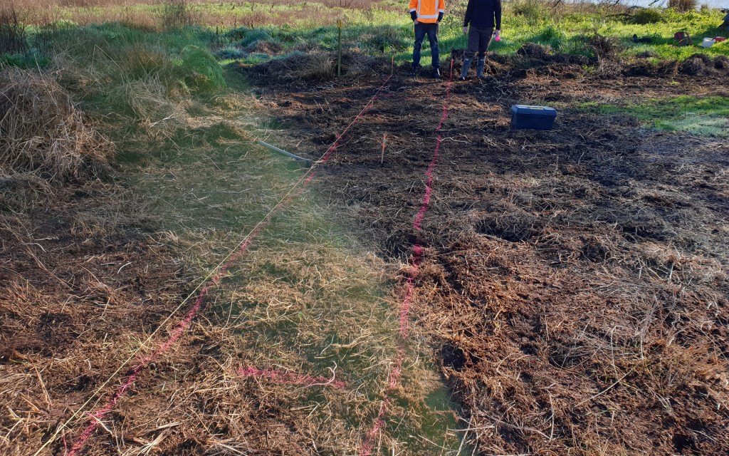
Deciding where to excavate, Photo by Zac McIvor, 27 July 2020
Desktop research: know before you go
Archaeologists do not possess X-ray vision (well, I don’t), so we have to gather as much information and tools as possible to make educated guesses where archaeological evidence is likely to be buried.
Kōrero
People with longstanding connections to cultural heritage places and surrounding lands usually hold information about where archaeological evidence is likely to be.
These people could be descendant’s of the people who made the archaeological evidence that you are interested in or the local land owner who inherited the land from her mother.
Humility is an essential part of a good archaeologist’s toolkit. By simply asking people about whether they have come across any historical rubbish pits eroding out of a bank, you can save a lot of time trying to figure it out for yourself!
Historical Information
The first step to anticipating where archaeological evidence will likely be is understanding the area’s local history. That information may come from published books, photographs, old survey plans, online records or descendants’ lips today.
These layers of information are essential to building a picture of where people did what in a landscape and, therefore, where physical evidence of those activities may be preserved.
For example, I have spent much time perusing historical survey plans and Māori Land Court records when assessing the potential for archaeological evidence in Waikato.
Archaeological planning can involve a lot of historical research to help determine where archaeological evidence is likely to be. Photo by Zac McIvor, 16 July 2020
Legacy data: what do we already know?
People, including archaeologists, have gathered information about cultural heritage places for decades. This information can be in the form of recorded archaeological sites on some form of databases like the New Zealand Archaeological Association’s ArchSite, reports and publications, old photographs, drawings or other forms of data.
There is no point in reinventing the wheel whenever you step outside, so building on what others have recorded is best. [insert giant shoulder standing proverb here!]
Excavation plan of Mangakaware 2 showing Peter Bellwood’s excavation trenches and palisade posts (excerpt from Bellwood 1978 ‘Archaeological Research at Lake Mangakaware, Waikato, 1968–1970’. Volume 12 Otago University Studies in Prehistoric Anthropology. Monograph 9 of the New Zealand Archaeological Association.
Aerial & Satellite Imagery
Some archaeological evidence is best seen from above. Images from planes, drones and satellites allow us to see surface features like terraces, building foundations or irrigation trenches that are difficult to see from the ground.
Images taken at different times can show how the landscape was once different from today. These datasets can also aid researchers in viewing hard-to-reach places.
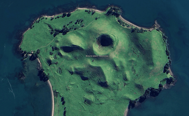
Can you pick out the terraces, agricultural alignments, defensive ditches and paths on Motukorea below?
Motukorea/Brown’s Island satellite image showing a surface archaeological landscape of Tāmaki Makaurau iwi. Photo by Google.
LiDAR: Shooting Laser Beams at the Ground
No, it’s not a space-age weapon – it’s LiDAR! Archaeologists shoot laser beams at the ground from aeroplanes, drones and sometimes from tripods on the ground to create super-detailed maps of the terrain.
Unfortunately (or maybe fortunately), you cannot see or hear the lasers, so it is perhaps less exciting than the image in your mind. However, the results can be remarkable and really helpful for archaeologists to identify potential archaeological evidence.
LiDAR can help to detect areas where people have changed the ground surface in some way, such as the construction of ditches, banks, walls, terraces, structures, water races or pits. You can check out its effectiveness in this review article by Josephine Hagan and Dr. Andrew Brown.
Here is a quick video explainer on the power of LiDAR in the Amazon, which has helped locate archaeological landscapes beneath dense rainforest canopies.
Field Survey: On the Ground with a Magnifying Glass and a Smile
Surface Evidence
Sometimes, archaeological evidence reveals itself to you directly, but you kind’a have to be there in person to see it.
Archaeologists have a sharp eye for artefacts and features on the surface. Whether it’s a mysterious ceramic fragment or a strangely shaped rock, these clues can help indicate buried evidence nearby.
That’s why surface inspection is one of the most powerful tools for archaeologists to know where to excavate. It is all good and well to use aerial imagery, historical records and fancy lasers, but it is generally helpful to go and inspect the ground surface.
Erosion, fallen trees and slumps can often expose buried archaeological evidence you can only detect by getting out in the field and using your eyes.
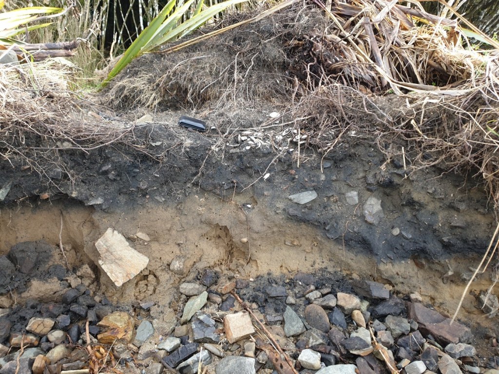
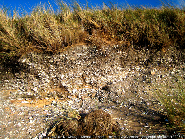
Example of a wāhi tupuna – archaeological site with shell midden, charcoal stained sediments and hāngi stones expensed on a Southland beach. Photo by Zac McIvor, 2022
Geophysical Techniques
Sometimes, all the above techniques are not enough to identify archaeological evidence. For all you know, you could be walking over layers of century-old human occupation without even knowing it!
A suite of techniques within the geophysics family can detect physical changes beneath the ground that people may have created in the past.
These changes could be making a fire that became buried, digging a trench, burying a person’s body in a grave or constructing wall foundations.
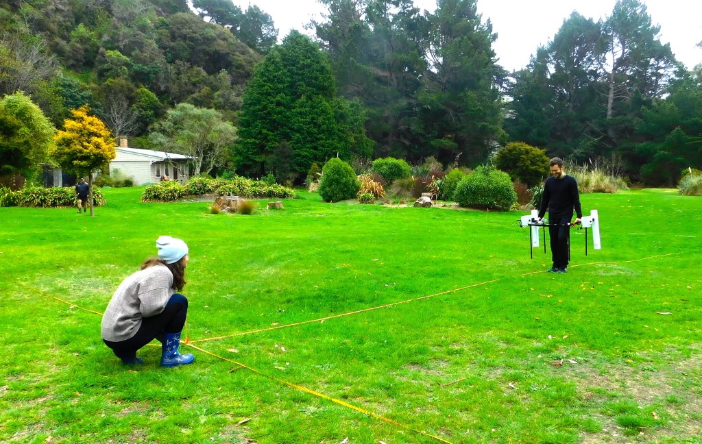
Anne Forde and I doing a magnetometer survey. Photo by Anne-Claire Mauger, 2022.
Let’s look at a few of these techniques:
Changes to the ground by digging or building things, or the burying of magnetic objects like volcanic rock or metal can alter the earth’s local magnetic field in a small way. Magnetometry is a tool that can detect these changes even when you cannot see any evidence of those modifications above ground.
Different materials resist electrical currents to different extents. Metals and sediments with high water content conduct electrical currents really well, while some rocks and dryer sediments can inhibit those currents. Resistivity arrays detect these subtle changes in the ground’s electrical resistivity.
Ground penetrating radar is another technique that sends radar waves below the ground to detect hard objects or changes in layers of sediment.
Ground testing
Based on all these techniques, archaeologists might have a hunch of where buried archaeological evidence might be.
This hypothesis can be tested by making small explorations into the ground — always following the local tikanga and legislative requirements.
Techniques range from using a metal spear probe to a spade-width test pit into the ground to detect changes in sediment colour, texture and compaction, and identify evidence of past human activity, such as shell (e.g. from midden), charcoal, burnt rocks, cultivated soils, glass or ceramic fragments.
All of these materials hint at there being further buried archaeological materials nearby.
Predictive Modelling: using maths before you dig
Now, I know what you’re thinking: archaeologists and math? By crunching data from known locations of archaeological evidence, the local environment, and cultural patterns, we can predict where other similar materials may be buried.
Predictive models have been used on a handful of occasions in Aotearoa New Zealand to determine the likelihood of development earthworks modifying or destroying archaeological evidence (e.g., Northland SH11 and Kāpiti Coast).
Usually, predictive modelling tools are less helpful when determining whether archaeological evidence is buried within the 10 meters or so around you. In those situations, the other techniques mentioned above may be more useful.
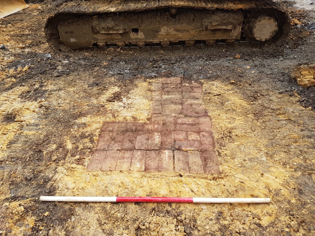
Even when you are really prepared, archaeology can be full of surprises, such as this late nineteenth-century garden path nestled beneath a concrete parking building in downtown Auckland!
Late nineteenth-century archaeological brick path preserved under a large concrete building. Photo by Zac McIvor, 2016.
Summary
So there you have it, intrepid explorers of history – the thrilling methods that archaeologists in Aotearoa New Zealand use to track down the whispers of the past. It’s a blend of high-tech wizardry, good old-fashioned research, a little bit of sifting through dirt and a sprinkle of luck.
To figure out where buried archaeological evidence is located (and sometimes decide where to dig), archaeologists use desktop research (including historical information, aerial photographs or LiDAR), field survey to inspect the ground, geophysics, small test investigations and predictive modelling.
In reality, archaeologists use a combination of these techniques depending on the constraints of the kaupapa (project, purpose).
Archaeologists have great power in identifying potential buried archaeological evidence – tapuwae o ngā tūpuna. Excavation is an invaluable tool to learn new things about the past, recover lost knowledge, or salvage evidence before it is destroyed by coastal erosion or a new road.
On the other hand, the excavation is destructive – no matter the detail in which the site was recorded. Therefore, archaeologists have a responsibility to only excavate when absolutely necessary and within the tikanga or culturally safe way of doing things of descendant communities.
Interested in engaging more with archaeology? Check out this post. Otherwise, subscribe to keep up to date with my next posts.
Middens are the most commonly recorded “archaeological site” in the Aotearoa New Zealand and one of the most frequently recorded archaeological features. They are important because they are physical connections to the past that promote a sense of connection and belonging, and a long term perspective on this country’s history. Through archaeology alongside Mātauranga Māori we can learn much about the past from midden.
People always ask heritage professionals and archaeologists working in Aotearoa New Zealand, have you been to work overseas YET?
I am sure Nigel over the fence was innocently inquiring about my career prospects to pass the awkward silence of our poorly timed Monday morning roadside rubbish bin dropoff.
But, it is a common question that I can’t shake from my mind as it implies an inevitability of moving to greener pastures, possibly suggesting that this country’s heritage and archaeology is uninteresting or unimportant (so why wouldn’t I move away?).
Well, thanks imaginary neighbour, Nige, for some blog inspiration.
Today, I want to focus on one key element of archaeology in Aotearoa: the humble “midden”. There are over 22,000 archaeological “site” records on the national archaeological site database, ArchSite, referring to a midden feature (among other features). That makes it one of if not the most commonly recorded archaeological feature in the country.
Part of the midden’s ubiquity adds to the common suggestion that archaeology in Aotearoa New Zealand is boring (so when will you work in Egypt?).
Today, we will explore the value of the humble midden and perhaps provoke some wonder about what we can learn from archaeology in Aotearoa New Zealand as a whole.
Vamos, Nigel, let’s go!
Shell midden — what are they?
The Merriam-Webster Dictionary etymology of the English word midden goes back to the fourteenth-century Old Norse word mykdyngia, literally meaning dung heap.
The modern spelling seems to have appeared in the early nineteenth century.
The messy connotation of midden is beautifully captured in the following metaphor in Practical Parenting (1989): “I’m still in my nightie at midday, the house is a midden, and I don’t even go out to work” (Oxford English Dictionary).
Archaeologists worldwide have used the term to describe archaeological piles and deposits of material interpreted as rubbish or waste.
In Aotearoa New Zealand, the term midden generally refers to deposits of shell that often include bone, stone artefacts, seeds, red ochre and charcoal. Today I will be focussing on midden made by Māori — tangata whenua.
Kia hiwa rā! Warning!There is an implication that these tangata whenua archaeological features were always just waste piles.
That is not necessarily always the case, which opens us up to a debate about using the term midden (a waste pile) in archaeology to describe a feature that may not have had that purpose at any point. Let’s not go there for now.
What do middens look like?
Landowners and people curious about why I strangely inspect eroded dunes challenge me when I declare a shell lens as an archaeological midden deposit – a physical remnant from a historical tangata whenua occupation in the area.
Fair enough! How do I know a midden from a natural shell lens? Sometimes I get confused too, but I have a few secret squirrel rules of thumb that I will share with you. Midden can have the following components:
Middens can appear as buried deposits but were often originally mounds or piles.
Several shellfish species from different habitats suggest people have gathered and deposited them there.
Other materials, in addition to shells, including bird, mammal and fish bone, stone artefacts (taonga kōhatu), charcoal, wood, kōkōwai (red ochre), ash, and rocks from fires and earth ovens (hāngi or umu).
Charcoal-stained sediment around the shells.
The shells, rocks, and bone may be burnt or have discolouration indicating they have been cooked.
Shell midden often but not always include variably fragmented shells.
Shells have been opened (particularly bi-valves like pipi and kūtai/green-lipped marine mussels). Lots of closed bi-valves are typical in natural shellfish beds.
They can form from one single event of deposited waste from an afternoon feed or be built up over weeks, years or generations and have multiple layers.
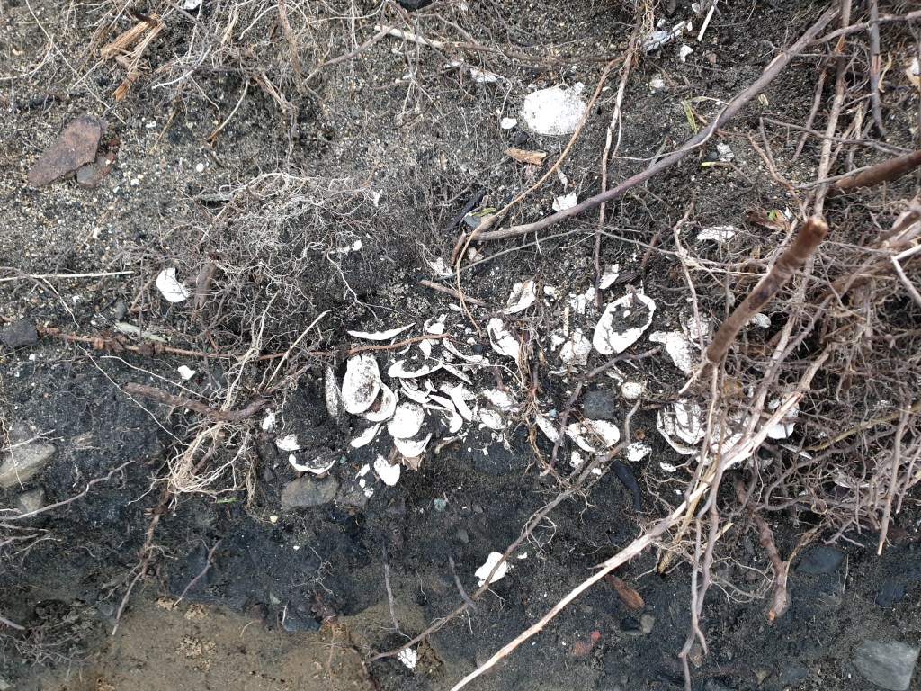
Photo by Zac McIvor.
Where are they located?
Generally speaking, you can find shell midden near the areas where their contents were collected. In this way, middens are more common along coastlines and waterways than inland. If a local tuangi (cockle) bed exists, historical midden will probably be buried in the dunes and hills nearby.
That being said, many midden have been uncovered a long way away from the coast. What do you think that might indicate? Hold that thought.
Why are middens important?
Like all archaeological evidence, middens are tapuwae o ngā tūpuna — sacred ancestral footprints. They are physical remains of former occupations by tanga whenua in your particular place.
Middens remind us (if needed) of the deep history of where we live and can be a meaningful physical connection of descendants (ngā kanohi ora) to those ancestors. The value of these places to tangata whenua must be defined by tangata whenua – like all communities, iwi, hapū, whānau, and individuals have different perspectives.
Through archaeological practice, we can learn much about past environments and historical activities by tangata whenua of an area. As always, such archaeological work should be done in collaboration or leadership of tangata whenua.
Shells often preserve well compared to other organic remains and are clearly visible when eroding from a dune bank. Therefore, midden can be a helpful indicator of other buried and more ephemeral archaeological evidence in the surrounding area.
Middens are the tip of the archaeological iceberg!
What can we learn from middens?
What was collected (and eaten)?
The most obvious thing we can learn from a midden is what people ate based on the remains of that kai. This evidence could include the shells of pipi, tuatua, kūtai (green-lipped mussels), kākahi (fresh-water mussels), or pāua, or the bones of kererū, hoihō (yellow-eyed penguin), kurī (dog) and tāmure (snapper).
A lucky (or unlucky!) archaeologist may also come across what those animals ate — usually kurī.
Yes, that’s right, fossilised poop (coprolites) is often preserved in archaeological deposits. They always bring a giggle and snide remark. Shouldn’t have had those chillis, mate 💩
Mature specialists can analyse the contents of those poops to understand what the kurī, for example, may have eaten. This information contributes to our understanding of relationships between people, dogs, and local environments.
When was the midden made?
Based on what shells and bones there are, you can begin to think about broader questions and bring in your knowledge of māramataka (Māori lunar calendar) and broader mātauranga Māori (knowledge).
Say there is kererū bone in a midden; you can sketch a picture of when the midden was created based on summer or autumn harvest times (depending on the region). Perhaps other types of shellfish and bone also indicate summer activity.
Aside from the season, you can use radiocarbon dating to explore when it was made in calendar years. Put simply, radiocarbon dating tells us approximately how long ago an organism (living thing) died based on the amount of different types of carbon within its physical remains (check out the vid for more info below).
Those physical remains are usually wood, charcoal, bone, shell and seeds. Many complex issues complicate dating, like whether you find the person funny, if lifestyles match up and whether you’re attracted to them… Oh yea, there are many factors to radiocarbon dating too. 🤣
You must be very careful to date the historical event you think you are, what material it is, whether the material has been disturbed or contaminated, whether you are dating the most recent part of the organism, and so on.
Once you tumble over those hurdles, you get a date in calendar years of when that organism died, i.e., when it was harvested or chopped down (but even that is not a given!).
Where were the midden materials collected from?
We can make simple hypotheses about where particular shellfish and shellfish were harvested from based on where their local habitats are.
Remember I asked you to hold that thought about what inland midden can tell you? Fish it back, please. On one level, marine shellfish remains found inland tell us that kai moana was brought from the coast.
But why did people bring it all the way inland? Perhaps the food was brought as koha (gifts) for a hākari by a guest hapū where they were hosted by tangata whenua tuna (eels) or kūmara. Or, maybe it was part of the seasonal movement of communities between different settlements within the same rohe (tribal territories).
Archaeology cannot necessarily answer these questions. Instead, I believe this is one space of many that Mātauranga Māori and kōrero (oral histories) about migrations, intermarriage, rohe and hapū formations, and general manaakitanga (hosting values) contribute knowledge about that past where archaeology cannot.
Aside from knowing the local habitat of the plant or animal remains you are looking at, archaeologists can also look at chemical signatures of bone, shell and stone.
We can determine where the stone source was based on its geochemistry or explore the whakapapa or history of the object itself. Many stone artefacts, for example, show evidence of having been used for many different things, including hammer stones, scraping tools, cores, toki, ornaments or heating stones.
When archaeologists systematically sample middens, we can explore whether specific sizes of animals and plants were harvested. Sometimes that may be an element of managing the environment (i.e., kaitiakitanga), and sometimes that may result in only specific sizes of animals and plants being available to harvest.
For example, a common question is whether there has been a change in the sizes of shellfish harvested from an area through time. I grew up fishing tāmure with my dad and brothers in the Hauraki Gulf. Within my memory, I have noticed a change in the size and density of tāmure that have latched onto my hook.
Looking at midden, we can explore these questions of changes in fish stock. There are many biases and problems with doing this, but archaeological features – ngā taonga tuku iho, ngā wāhi tupuna rānei – provide an essential source of information for kaitiaki katoa (all stewards) seeking to understand past environments and how they have changed (this was done in a recent study in Northern New Zealand).
And so much more!
Other things we can learn from middens include the following:
Micro-fossil evidence in the sediments can tell us what plants may have been growing in the surrounding area when the midden was made – e.g., whether there was a primary forest or a kūmara cultivation.
The types of charcoal present can tell us about whether specific species of timber were chosen or what was available locally.
Material culture, including carved objects, tools and ornaments, can be analysed for their commonalities and differences regionally and through time.
Evidence of animals now extinct in an area, such as moa or seals.
Microfossil material in sediment can tell us what the surrounding environment was like at the time the material was deposited.
Does every midden matter?
On the one level, midden are wāhi tupuna. They are physical manifestations of whakapapa, providing a tangible link to historical connections between tāngata (people) and whenua (land). On this level, only those whānau, hapū and iwi can attest to those places’ significance.
On another closely related level, middens are repositories of rich information. Through archaeology, we can explore the timing and nature of historical occupations in the area; what was harvested and when; whether there was change through time in harvesting and environmental management; and how far people travelled to collect those resources.
From these simple morsels of information, we can explore why the midden was deposited there, whether it was associated with an important feast and the offerings of a visiting hapū perhaps.
We can also consider the broader array of objects and materials that would have been used to collect, process, use and deposit the materials. If there are kererū bones, consider what is not there but would have been there. The bird spears or snares, the kete, the time of year they were harvested, the karakia uttered, and the setting aside of the first birds for the tōhunga.
We cannot necessarily test whether these actions occurred using archaeology. However, Mātauranga Māori – knowledge about how people engage with their environments and the values behind that engagement is invaluable to exploring this in the past.
Thank you for reading this post. What do you think of when seeing midden? Do you connect with them in ways that I haven’t spoken about? Leave me a comment below or flick me an email e hoa mā. Mauriora.
Cultural heritage places are locations that we value and that we have inherited from previous generations.
Cultural heritage places are important in Aotearoa New Zealand because they do the following:
tell an important part of the human story of migration and human-environmental interactions.
show local histories in which the descendants of early Polynesian voyagers became hapū and iwi of today and the local origins of Pākehā and tauiwi (non-Māori, immigrant) settlement.
promote peace and intercultural understanding.
foster recognition and reconciliation of past grievances.
contribute to identity, a sense of belonging, and wellbeing.
attract tourists.
help to educate the next generations.
Don’t miss the critical conclusion at the end of the post!
Before coming to this page, I wonder what your answer would be to the question, why are cultural heritage places so important in Aotearoa New Zealand?
Perhaps you may immediately wonder what is a cultural heritage place? Mighty question that one.
Maybe you are thinking of all the places central to our national identity. I can see thought bubbles rising above your noggin showing the Waitangi Treaty Grounds, the Kerikeri Mission Station, or early Polynesian nohanga (settlements), such as Wairau Bar in Te Tau Ihu (Neslon-Marlborough).
Further still, you may have considered the shortness of our history and wondered whether much of interest has happened on these shores compared to the vastness of historical happenings in India, Mesoamerica, or Eastern Africa.
Whatever your perspective, you will come away from reading this post with seven key reasons why cultural heritage places in Aotearoa are so incredible and worthy of celebration, protection, reverence, and engagement.
The first stop in our understanding journey is Clarification Bay! Welcome aboard.
What is a cultural heritage place?
It seems like a bit of a dusty term that academics use. Let’s break it down.
Heritage can pretty much refer to anything that is of some value to you or others (individuals, communities, or society) that has been ‘handed down’ from a previous generation.
I like to think of heritage with the phrase taonga tuku iho. A taonga can be anything of value or interest to you. Tuku is to pass on or descend. Iho is from above or downwards.
Together, taonga tuku iho are those treasured things passed down to us from previous generations — A.K.A heritage!
I used the term things, but heritage or taonga tuku iho are more than objects. Heritage includes knowledge, practices, places, lands, natural resources, language and more. Just like taonga (see Te Tiriti o Waitangi!), heritage is very broad.
Today I am just referring to heritage associated with past people (cultural) that is place-based — whether it is a gold miner’s hut or a wāhi tapu associated with the taniwha of your hapū.
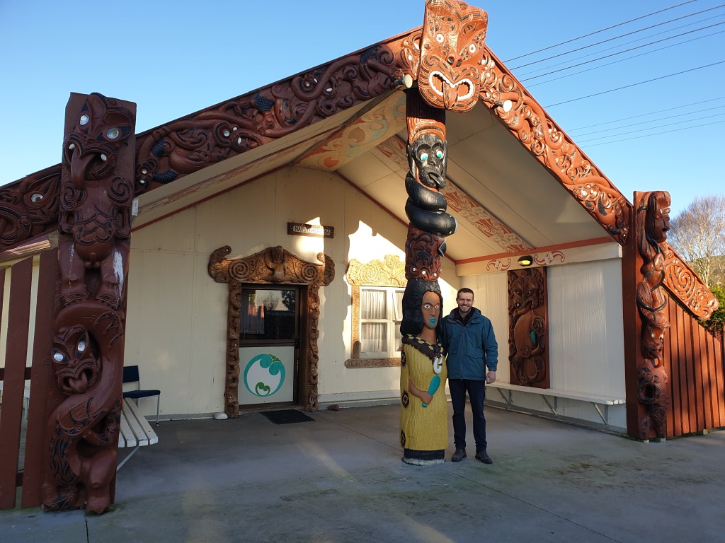
See below for an example of a cultural heritage place: Marutehiakina Whare Tupuna at Pūrekireki Marae, Pirongia, where I had a wānanga (workshop). The primary hapū of this Pūrekireki is Ngāti Taramatau (with connections to Ngāti Apakura) of Ngāti Hikairo, with further affiliations with Ngāti Maniapoto and Waikato.
Apakura and I, Marutehiakina Whare Tupuna, Pūrekireki Marae, Waipā
Taken together, a cultural heritage place is a location of some value to individuals or communities today that is associated with a previous generation. They are the locations binding the past before us in the present.
Archaeological sites are one form of cultural heritage place and have physical materials that you can study to learn more about the past (more on that here).
Okay, so why are they important? Keep reading and find out 😉
1. The book of humans
If you ask an archaeologist why archaeology in Aotearoa New Zealand is important, I would happily place a dollar or five on the likelihood that they would raise its contribution to the human story.
That human story is a migration story – a really long road trip! It is one version of our shared history based on research into archaeology, ancient DNA, linguistics and oral histories.
One of the early chapters details how certain groups of our species, Homo sapiens, left Africa about 100k years ago. Communities of people spread all over – from the Middle East, to Europe, across Asia to Australia and the Americas. It is quite an epic tale.
The last few chapters of migration
Within this metaphorical book, a significant section explains the incredible feats of Austronesian-speaking voyagers who traversed and populated the vast expanse of Oceania – the Pacific Ocean, Te Moana-nui-a-Kiwa.
From Southeast Asia over thousands of years, the voyagers successfully crossed formidable ocean gaps. Indeed, the high seas became the highways of the Pacific.
Some settled and became the ancestors of modern Indigenous Peoples in the Western Pacific. Others continued on the epic migration, following the practices of their ancestors.
Eventually, they arrived on the islands given the eclectic names of Aotearoa, Te Waipounamu, Rēkohu, Te Ika-a-Māui, Te Waka-a-Māui, Nu Tīreni, or New Zealand.
Sometimes the cultural heritage places may be investigated using archaeological techniques (under the mana/authority and tikanga/norms and protocols of tangata whenua). If you are interested in learning more about archaeology, check out this post.
The metaphorical footprint, the cultural heritage places, of the Polynesian voyagers whose descendants became the various whānau, hapū and iwi of today, are significant places. They are markers, physical reminders within the book of humanity.
We know from whakapapa (genealogies) and archaeological evidence that Aotearoa New Zealand was settled in the second half of the thirteenth century. More on that another time.
Meanwhile, people have lived in other parts of this blue marble we call home for tens to hundreds of thousands of years!
Common questions that researchers are interested in are how do people interact with their environments? How does that interaction change through time? How did the environment change after people arrived and began managing that landscape? How did the changes in the environment then affect how and where people lived?
There was a fairly rapid change in the environment when Polynesian voyagers arrived in Aotearoa and their descendants settled the islands. These dynamics include areas of forest clearance, technological innovations in food storage, active management of local vegetation and cultivations, and animal extinctions.
The relatively short time period of settlement in Aotearoa makes it possible for environmental researchers to explore the above questions in ways that are not possible in areas that have been settled for much longer periods.
Through archaeology, cultural heritage places in Aotearoa are contributing to that broader human narrative of interacting with the environment through time.
Check out (video below) the recent excavations on sub-antarctic Enderby Island in the Auckland Islands group (Motumaha/Maungahuka). This is a current example of how cultural heritage sites are contributing to the human story. I was lucky enough to join!
2. Understanding our origins
Okay, recognising the overall human story is important and a worthy task. BUT, we do not have to define which cultural heritage places are important to our families and communities from what international circles have said might be important to humanity as a whole.
Although the Nazca Lines in Peru or the Imperial City in Beijing are internationally significant, often those places that are more significant to us are those closer to home – those places that contribute in some way to our local histories.
Nasca Lines aerial photograph, Peru. Photo by monikawl999
Mātauranga Māori, archaeology and written histories of and about cultural heritage places in Aotearoa contribute fundamentally to our local histories about who we are – here in Aotearoa specifically.
Examples of knowledge that have come from cultural heritage places include:
adaptation to new technologies, from the plough and mill, to nails and muskets, which changed the lifeways of Māori communities forever.
British invasion and war, pastoralism, gold mining, flax milling – pick a point in history and there will be some form of cultural heritage place associated with it.
So much of our understanding of the past in Aotearoa comes from cultural heritage places. Much more than being essential chapters in the human story, the cultural heritage places in Aotearoa New Zealand are central to our local story.
3. Peace: tolerance and respect
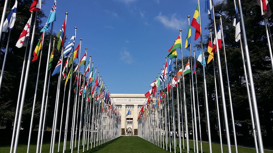
Forgive me for a moment. I need to return to the global level again, and when I say global level, I mean… [pause for effect]… [cue trumpets]… The United Nations [cue image of gently waving national flags].
Let’s take it back 78 years to the great year of 1945 – the year that World War II was thankfully called off after years of slaughter and suffering.
The people of the world considered that earlier long-term peace attempts after WWI didn’t play out too well, so the United Nations established UNESCO [release the doves].
UNESCO is the United Nations Educational, Scientific and Cultural Organisation. It is an agency within the UN that maintains world peace and security through… well, sharing just that — education, science and culture.
The basic idea is that war and conflict come from differences in culture, opinion or perspectives. If we are all a little more understanding of where people are coming from, there will be less tension and less potential for a third world war. Touch wood! At the same time, I acknowledge the suffering and war that many parts of the world are facing this very minute.
Alright, Zac, but what does UNESCO have to do with our cultural heritage in Aotearoa New Zealand? Great question!
We do not have to go long in our day to be reminded of the strange tension in our lives. It may be a session on geopolitics on the radio or a moment of weakness leading us to a Facebook comment section.
Whatever the issue at hand, people are fence-sitting less. We are becoming more antagonistic and less forgiving of those who disagree with us on which way a toilet roll should go on its holder.
I think that we can remind ourselves of the original purpose of UNESCO’s recognition of the World Heritage Convention.
Through sharing, visiting, engaging, commemorating and protecting our cultural heritage places we will walk in the direction of greater harmony, while fostering diversity and the complexity of perspectives that come with a healthy, democratic society.
It’s not all sunshine and daisies though. Although some cultural heritage places should be celebrated for their histories, others locate dark events that are equally essential to be remembered.
As the nation’s current cohort of students passes through the new history curriculum, they will be exposed to horrible narratives of colonialism, death, discrimination, and atrocity.
These scars on the history of this country may incite pain, anger, or discomfort. However, it is necessary for these histories to be acknowledged and remembered.
The cultural heritage places where these dark histories occurred become places that are returned to by the victims’ descendants, to reflect, to acknowledge.
It is through these embodied sensations of historical wrong that we are driven, perhaps in spite of our personal interests, to reconcile those wrongs as a country. At the very very least, cultural heritage places help us to recognise that those events REALLY occurred at a REAL place and have caused REAL inter-generational trauma.
An example of the power of cultural heritage places in the process of recognition and reconciliation is the beginning of Te Pūtake o te Riri: He Rā Maumahara (the commemoration day of the wars between the Crown and Māori):
5. Wellbeing and identity
It feels good to know who you are and where you are from.
We can be reminded of our identity through spending time with family and friends, listening to music recordings of what we were raised on as kids, or returning to important places passed on to us by our forebears.
These places may be your Dad’s marae, your town’s war memorial with your great-grandfather’s name inscribed, or perhaps your hapū’s ancestral pā.
There are significant personal and communal well-being benefits from having a strong relationship to cultural heritage places.
So what does having a strong connection look like?
Well, it could be by visiting them regularly, performing ceremonies there or researching more about them.
Without these connections, wellbeing can be negatively affected as has been experienced by the effects of colonisation, land alienation, destruction of heritage sites or inappropriate use of these sites. That being said, there is always potential for the building up of that wellbeing through reconnection.
Cultural heritage places are so important as places to connect to our ancestors and reinforce our sense of self.
Photo by Isaac McIvor
6. Cultural tourism
Another reason why cultural heritage is important is because of its tourism potential.
Visiting the cultural heritage places on offer is one draw card for tourists. Not just to the country, but to the regions.
Tourist destinations are sometimes nationally showcased and funded by the New Zealand Government. The Tohu Whenua programme is one such example and is a visitor program intended to connect Kiwis to their heritage, increase national identities and enhance wellbeing.
Due to the tourism potential, cultural heritage places are an economic development opportunity for Indigenous or non-Indigenous communities — and not only for economic gain.
Many ventures may be entirely non-profit. Instead, they are places where history and culture are shared for all while resourcing conservation, protection, and revitalisation efforts.
Cultural heritage places are also places for education. As the country grapples with teaching the new history curriculum to the next generation of citizens, it is so important to incorporate cultural heritage places within those programmes.
Education physically in a location where events occurred is a powerful way of teaching. It instils the significance of cultural heritage places within the student, which builds personal identity and enables students to explore new relationships with places already familiar to them.
If you are wondering why Aotearoa New Zealand cultural heritage sites should be taught in schools, I will kindly ask you to re-read this post.
Check out Prof. Wally Penetitio’s (Ngāti Hauā) insights on place-based education:
Important conclusion #readthis
Cultural heritage sites are extremely important in Aotearoa New Zealand. They provide a human-level and local history perspective, bring peace and understanding, enable recognition and potential reconciliation of dark histories, inspire a positive sense of wellbeing, and are potential locations of tourism and education.
So why is it so essential for you to know they are important?
Because they need to be protected, learnt about, respected and celebrated. They deserve formal recognition and to be defended from our growing developments. They are worthy of well-resourced kaitiaki, archaeologists and heritage practitioners to care for, understand and share them.
Archaeological sites, particularly, are finite and ultimately gone forever if destroyed. Unlike a tree that is cut down, you cannot plant more archaeological material (in situ and of the same age!). Once they go, they will go forever; not only for us, but for all of our unborn descendants.
Okay, okay, point made.
Thank you for reading this post! If you like what you have read and would like to see more of this content, please let me know, like, subscribe and share!
Here are seven ways you can get involved in archaeology in Aotearoa New Zealand:
Visit sites in person.
Speak to people who have knowledge and experience of those places.
Research content online.
Watch documentaries and listen to podcasts.
Volunteer your time and skills.
Join relevant organisations, social media pages, and attend events.
Consider becoming an archaeologist yourself!
Join me in exploring these opportunities below (there are heaps of external links too).
Alright, alright, alright, quiet down… I hear you. You want to marinade in what archaeology might have to offer, but you aren’t quite sure how to engage with it, right?
Perhaps you have tried to search a bit about archaeology in Aotearoa New Zealand, and have been hit with 30-page pdf documents and dusty references behind a paywall.
Maybe you want to give your Tinder swiping muscles a break with some vertical scrolling…
Whatever your situation, whakatata mai, gather around the fire all close-like and let’s go through 7 ways that you… No, not you. The person next to you. Yes, you! can engage with archaeology.
Spoiler alert! You don’t have to be an archaeologist to be involved.
Although archaeological information is predominantly stored in books, journal articles and lots of reports, the best way to experience archaeology is by pocketing your phone and heading out onto the whenua – the land.
Bilbo Baggins had great wisdom in recognising the “dangerous business” of “setting out your door”. However, in this case, that is the best way to engage with archaeology.
Why is that? Well, if you read my first post (go on 😉), you’d know that archaeological remains are the material evidence of past human activity. The best way to experience that material is through using your bodily senses — by physically being in the landscape in which those remains are located.
I don’t mean to encourage you to jump your neighbour’s fence and start digging – far from it. Under current legislation, excavation (or any form of disturbing) should only occur under specific circumstances, led by experienced practitioners, and with support from the tangata whenua and the Crown (in its various costumes). More on that another time.
Just stick to looking, listening, and maybe take your shoes off to be a little bit closer… I guess you can smell, too, if you are into that. But, e hoa, please put your garden trowel away for today, stick to public property, don’t pick up anything you find, and always be respectful of the place you are visiting, ngā kanohi ora tangata whenua (living Indigenous Peoples) and the ancestors of that place.
All I mean to say is that by going out into the landscape and visiting archaeological remains that are visible, you can engage with the past in a way that may be difficult if those remains weren’t there. Each place provides some visceral link to the past that would be lost if they were all replaced by another parking lot.
That evidence may be the rua kūmara tupuna (ancestral sweet potato storage pits) on your whānau land, the local historical post office repurposed as an Irish pub, the shell midden eroding out along your local bush track or the schooner shipwreck that pokes its ribs proud during low tide at your local beach.
Of course, we will all sometimes have shockingly different experiences when we walk the land. One influence of that diversity is how much each person knows about the history of a place, who made that history, your connection to it and what evidence you can see of it. How convenient – a segway.
2. Kōrero (me whakarongo)
Speak (and listen)
Some of my most memorable and educational engagements with archaeology have not actually been while excavating or using any of the techniques I mentioned in last week’s post. It came from walking the land with kaumātua (elders) – both those of my whānau and those I have had the privilege of spending time with as a heritage dude.
I might be cheating a bit by bringing point 1 of engaging with archaeology into point 2, buuut being out there, walking the footsteps of a previous generation, while hearing kōrero tuku iho (oral histories passed down) from the lips of the knowledge keepers is a remarkable experience.
We should never take for granted the affirmative power of engaging in archaeological and heritage spaces and the people that hold those places dear.
Ōākou Wānaka May 2023, Heritage New Zealand Pouhere Taonga
The same goes for learning about any heritage sites from the people bound to those places – be it your uncle who has spent the last decade pulling together your family histories or the keen bean gold miners running the local historical mining visitors centre. I would take human connection over a pdf document any day.
My point is that engaging with archaeology does not have to be done by practising archaeological techniques. Meaningful connections also come from learning ā-tinana, in person, from those with living knowledge about those places.
3. Read, read, read 🤓
For better or for worse, archaeology is part of the academic convention which produces A-LOT-OF-WRITING. Text may be in the form of peer-reviewed journal articles and books; assessment, survey and excavation reports; or the vast array of mostly volunteer records housed within the New Zealand Archaeological Association’s Digital Site Recording Scheme known as ArchSite… phew, that was a mouthful.
What does this archaeological information actually look like? Well, it can be anything from observations made during an archaeological survey, photographs and drawings of excavations, interpretations of lab-based analyses of stone, bone, shell or ceramic artefacts, radiocarbon dates, or historical overviews of the human settlement of the whole country. The list goes on.
Now I can sense you are beginning to back away slowly. Some of the information may be pretty dense, irrelevant to you or costs too much money to access. I hear you! For that reason, I have prepared a short list of sources that are free or worth tracking down at a library to start you on your journey:
The quarterly Archaeology in New Zealand (AINZ) newsletter;
New Zealand Journal of Archaeology;
NZAA Monographs; and
Special publications.
The Heritage New Zealand Digital Library is a digital repository of archaeological assessment, survey and excavation reports primarily associated with the archaeological authority process under the Heritage New Zealand Pouhere Taonga Act 2014. These are searchable and downloadable for free in pdf format. The new and improved Heritage New Zealand Pouhere Taonga website is also worth an explore while you are there!
Tangata Whenua: An Illustrated Historyis a book by Aroha Harris, Atholl Anderson and Judith Binney. Anderson’s chapters are heavily based on Māori archaeological information but are accessibly presented and beautifully illustrated. Try your local library for this one, or get a copy for your shelf.
The Journal of the Polynesian Society is searchable and free to access online for volumes from its establishment in 1892 to today. This journal contains invaluable archaeological information about tūpuna Māori and cultures in the broader Pacific. The society has a colourful history, including scholarship from monumental Māori scholars, such as Pei Te Hurinui Jones, Te Rangi Hīroa and Apirana Ngata. It also contains many debunked accounts by early colonial ethnographers and archaeologists, such as the society’s co-founder S. Percy Smith. Read these with a critical eye.
Archaeopedia: New Zealand is a free wiki website for people interested in New Zealand and Pacific archaeology.
Blogs are also a great source of information about archaeology. I mean, you are here, aren’t you! Check out Christchurch Uncovered and The City Remains for the archaeology of Christchurch, The Past From Above for digital and cartographic (maps!) archaeology, and Faunal Girl for the archaeology of animal bone, teeth, and shell in the Pacific.
Lastly, you can sign up for Heritage New Zealand Pouhere Taonga’s shiny, quarterly Heritage magazine, which presents various projects and people involved in conserving and protecting our heritage places and objects. This is a paid subscription.
“Meaningful connection also comes from learning in person from those with living knowledge about those places“
4. Watch and listen
I know we all get tired eyes from all that reading or love a good podcast to drone out your dog yelling at you to throw the ball at the dog park… just me?
Aotearoa Unearthed is a fun podcast on NZ archaeology for the whole fam, with archaeologists interviewed on topics from tūpuna repatriation to colonial infrastructure.
Artefact is a documentary presented by our national treasure, Anne Salmond, on several significant objects and their stories.
Join Te Reo revitalisation giant, Scotty Morrison, on his journey of learning more about the earliest ancestors in Aotearoa in the documentary series, Origins. Of course, these documentaries include more than archaeology, but archaeology forms part of the mosaic of knowledge presented.
5. Volunteer
There are also ways to get your hands dirty figuratively and literally by volunteering your time to help heritage and archaeologist professionals. Believe it or not, archaeology in Aotearoa New Zealand has a strong tradition of volunteer or “amateur” involvement. If you develop skills or you bring skills to the table, you may even be a desirable employee!
Unfortunately, there are no official structured volunteer programmes in Aotearoa. The small industry size probably has a lot to do with this. However, that’s not to say there are no opportunities out there.
Volunteer initiatives are project-specific and often driven by poster-worthy, admirable (in my book) champions with a passion for community involvement. Here are a couple of recent projects that have had a strong public engagement arm:
The 2021 HMS Buffalo Re-examination Project undertook a detailed underwater survey of the HMS Buffalo shipwreck in Whitianga, New Zealand.
2017 Mangahawea Bay Partnership Programme between Ngāti Kuta and Patukeha, Te Papa Atawhai/Department of Conservation, University of Otago and Heritage New Zealand Pouhere Taonga. This involved excavations at a place of Polynesian settlement on Moturoa, Ipipiri (Bay of Islands).
Te Karere TVNZ story on the archaeological excavation at Mangahawea
More occasionally, individual archaeologists and heritage practitioners may welcome assistance with whatever fascinating tasks they have ahead of them.
If you would like to get involved, I recommend to you, dear reader, to build relationships with your local archaeologist. That being said, please do respect that not all projects are appropriate for public involvement due to ethical considerations, time and funding constraints, or health and safety risks. Be a champ and respect any declines you receive.
Archaeologists can be hesitant at first. Best not to look ’em in the eye. A coffee in hand helps whilst performing a courtship dance. Here are their local habitats:
Few district and regional councils have archaeologists on the books. The largest crew is within the Auckland Council Heritage Unit.
6. Join the community
The next way to get involved with archaeology is to engage with people already interested in archaeology, heritage, wāhi tupuna, or ancestral places. What are these communities?
The New Zealand Archaeological Association (NZAA) is a not-for-profit, registered charity organisation run by volunteers. Members of NZAA include professionals, amateurs, students, schools, charities and other organisations with an interest in the archaeology of Aotearoa New Zealand.
Receiving the quarterly Archaeology in New Zealand newsletter.
Receiving discounted rates at the annual NZAA conference. The conference is the Association’s highlight of the year, where everyone gets together to share research, wānanga (workshop, reflect and discuss) current issues and go on field trips.
Ability to apply for your site recording project to be funded by the Walton Fund (up to $1,000).
If you are an archaeological consultant, you can be listed in the consultant’s directory.
NZAA also organises the annual New Zealand Archaeology Week (usually announced on their news page). Who would’ve known we had such a national week! Now you do!
ArchWeek’s purpose is to showcase the importance of archaeology to the public by hosting events across the country, including presentations, field trips, excavation and lab open days, exhibitions and online content. The week is usually in April, so keep an eye out to see what’s going on in your area.
Generic fieldschool photo (U.S. Army Photo by Scott T. Sturkol, Public Affairs Office, Fort McCoy, Wis.)
In addition to NZAA, there are a bunch of keen beans and knowledgeable people on the Aotearoa New Zealand Archaeology (ANZARC) Facebook Page. All things archaeology and heritage are shared there, and all non-trolls are welcome.
7. Become one
The final way to engage with archaeology in Aotearoa New Zealand, or anywhere for that matter, is to train to become an archaeologist. The pathways into archaeology deserve their own post, so I won’t go into any detail here. But basically, you can train to become an archaeologist by getting a tertiary qualification through the archaeology programmes of Te Whare Wānanga o Ōtāgo University of Otago or Waipapa Taumata Rau University of Auckland. You can also study overseas too.
Summary
There are many ways to engage with archaeology. I have identified seven key ones, which are mostly free – well, not the tertiary study part! We can dream…
These seven points can be boiled down to researching the archaeology in your area, visiting places (where publicly accessible and appropriate), and engaging with others who are just as keen about the past before us as you! That includes listening to people knowledgeable about the area and its significant places, reaching out to archaeologists to be involved where possible, joining the community online or through NZAA, or training to become an archaeologist yourself.
If you are embarking on your archaeology journey (as a profession or general interest), I hope you feel a bit more informed about how to continue it. If you feel this information has been helpful, please subscribe, like and share it with those who may also benefit.
Feel free to leave comments below. I would love to hear what content you want to read about next.